RTK corrections in Montana
RTK Premium delivers RTK corrections in Montana in NAD83(2011), epoch 2010.0, over standard NTRIP. It serves the best solution available at each site: a network (VRS) solution where one exists, and corrections from the nearest reference station where none does, as across much of western and central Montana, where accuracy depends on the distance to that station. It costs $900 per device per year, or $690 for RTK Core on a single network, and a 14-day free trial comes first. Much of eastern Montana has no RTK Premium network today, so check each site on the coverage map.
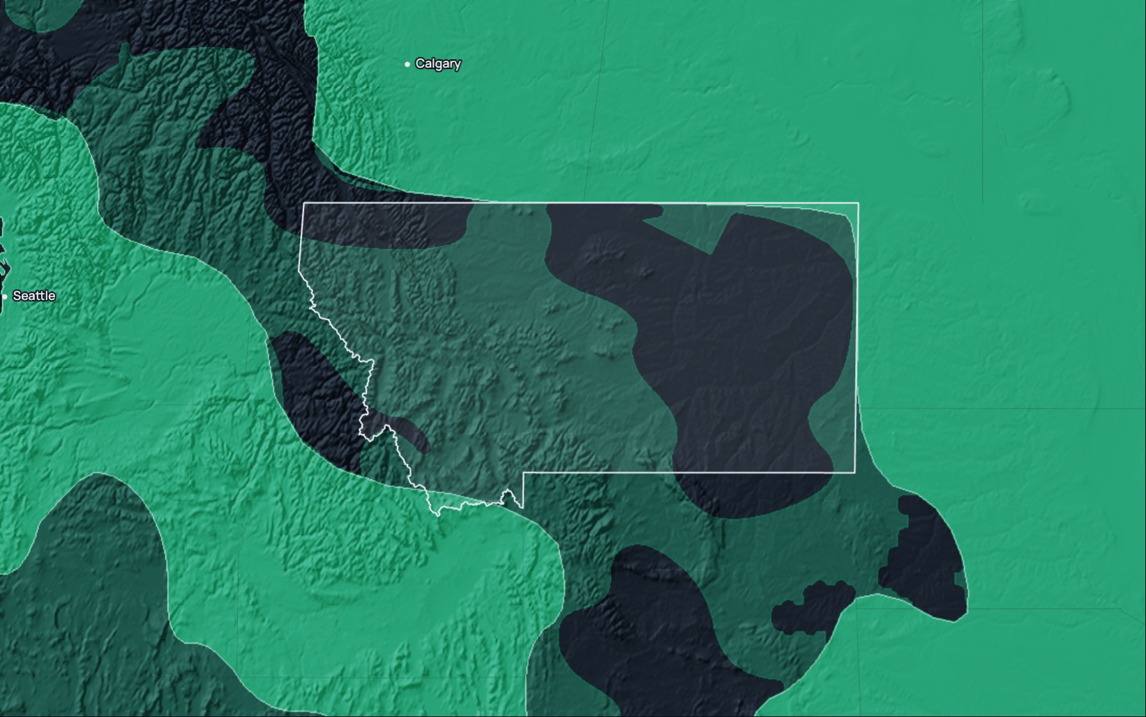
RTK Premium in Montana
| Coverage | The coverage map shows networks over about 56% of Montana's land area, nearly all of it 1 network, and no network across much of eastern Montana. Across much of western and central Montana, RTK Premium's corrections come from the nearest reference station rather than a network solution, so accuracy depends on the distance to that station; check your site on the map |
|---|---|
| Frame | NAD83(2011), epoch 2010.0; ITRF on request |
| Accuracy | Under 1.5 cm horizontal, 2.5 cm vertical, in a fixed solution on network RTK; on the nearest-base stream, accuracy depends on the distance to the reference station |
| Service level | The 99.9% monthly service level for RTK Premium applies only in Eligible Areas, which need 2+ networks on the coverage map; most of Montana is served by 1 network |
| Trial | 14 days on your own receiver; your account arrives by email within two working hours |
| Price | In the US, RTK Premium costs $900 per device per year, RTK Core $690 and RTK Access $350, excluding sales tax. Monthly plans run from $39 to $100. |
| Support | Business days, 01:00 to 15:00 Mountain Time (09:00 CET to 17:00 ET) |
| Stream | RTCM 3.x over NTRIP; caster rtkpremium.xyz, port 2101, mountpoint COMMON |
Check it before you commit
Setup guides
More than 100 step-by-step guides cover receivers, controllers, drones and machine control.
Test it yourself
RTKTEST.com compares up to three correction services against a surveyed point in one 15-minute session, and the 14-day trial runs on your own receiver at your own sites.
Correction services in Montana
Montana crews choose between the state's real-time network, commercial network RTK, crowd-sourced base stations, satellite-delivered corrections and their own base.
| Type | Typical operator | What to check |
|---|---|---|
| State network | The state library with the state DOT, counties, tribal nations and other partners, on a paid subscription. | Coverage near your sites, whether an availability commitment is published, and support hours. |
| Commercial network RTK | A private provider with stations across several states. | How many correction sources serve your area, the published service level and its remedy, and the term. |
| Crowd-sourced network | Independent owners hosting single base stations. | Distance to the nearest base, station uptime, and how each base was surveyed. |
| Satellite or state-space (PPP-RTK, SSR) | A provider broadcasting an error model without a local base. | Convergence time, accuracy and vertical performance. |
| Your own base | Your crew, on a surveyed point. | The survey of the base point, range, and the time spent setting it up and guarding it. |
Coordinates and heights
RTK Premium delivers NAD83(2011), epoch 2010.0, on every Montana connection, and ITRF on request. Montana uses a single State Plane zone under NAD83, which covers the state. Set the project, the controller and the correction service to the same frame and zone before the job starts.
Setup
- Start the 14-day free trial on this site, or order a subscription. Your account arrives by email within two working hours.
- Enter the caster rtkpremium.xyz, port 2101 and mountpoint COMMON in your controller or receiver, with the username and password from your account.
- Measure a control point you trust before the job starts, and compare the result with its published coordinates in your project's frame.
Industries using precise positioning or RTK corrections in Montana
Wheat: Montana farmers harvested 4,945,000 acres of wheat in 2025 and produced 182,220,000 bushels, worth more than $918 million. Seeding, spraying and harvest across those dryland fields run on guidance lines that need to match pass after pass. (USDA NASS, State Agriculture Overview, 2025)
Cattle: Montana had 2,140,000 cattle and calves on January 1, 2026, including 1,232,000 beef cows. Fencing, stock-water lines and irrigated hay ground on those ranches are laid out from surveyed points. (USDA NASS, State Agriculture Overview, 2025)
Roads: Montana had 74,705 miles of public road in 2024, and federal agencies were responsible for 13,930 of its 70,023 rural miles. Grading, culvert work and resurfacing on those roads are staked and checked against design. (FHWA, Highway Statistics, Table HM-10, 2024)
Coal mining: Montana's 4 coal mines produced 26,983 thousand short tons of coal in 2024. Pit benches, haul roads and reclamation grades at those mines are surveyed and staked against the mine plan. (U.S. Energy Information Administration, Annual Coal Report, Table 1, 2024)
Questions about RTK in Montana
Which RTK correction service serves Montana?
RTK Premium serves Montana with corrections from the nearest reference station across much of western and central Montana, where accuracy depends on the distance to that station, and much of eastern Montana has no RTK Premium network today. The coverage map shows which sites have a network.
Is there a free RTK network in Montana?
The state's real-time network, run by the state library with the state DOT and other partners, charges a subscription fee. Community networks run free single base stations of varying quality, so check the distance to the nearest base and how it was surveyed before you rely on it for paid work.
How much does RTK cost in Montana?
RTK Premium costs $900 per device per year, RTK Core $690 and RTK Access $350, with monthly plans from $39 to $100, excluding sales tax.
Which reference frame and zone do I use in Montana?
RTK Premium delivers NAD83(2011), epoch 2010.0, with ITRF on request. Montana has a single State Plane zone, so project the coordinates into the Montana zone for every site in the state.
Do I need my own base station?
Network RTK needs none, because it builds the correction for your position from the surrounding stations. On the nearest-base stream, a site far from the station may do better with a base of its own, so measure a known point near the site first.
How does RTK Premium choose the correction in Montana?
RTK Premium serves the best solution available at each site: a network (VRS) solution where one exists, and corrections from the nearest reference station where none does, as across much of western and central Montana. There, accuracy falls with distance from the station, so measure a known point near the site before the job starts.
Can I try it before I buy?
Yes. The 14-day free trial runs on your own receiver and needs no payment.
Last updated: 12 November 2026
Try RTK Premium in Montana
Run the 14-day trial at your own Montana sites, and measure a known point near each one before you commit to a plan.