RTK corrections in Latvia, on 2+ networks across most of the country
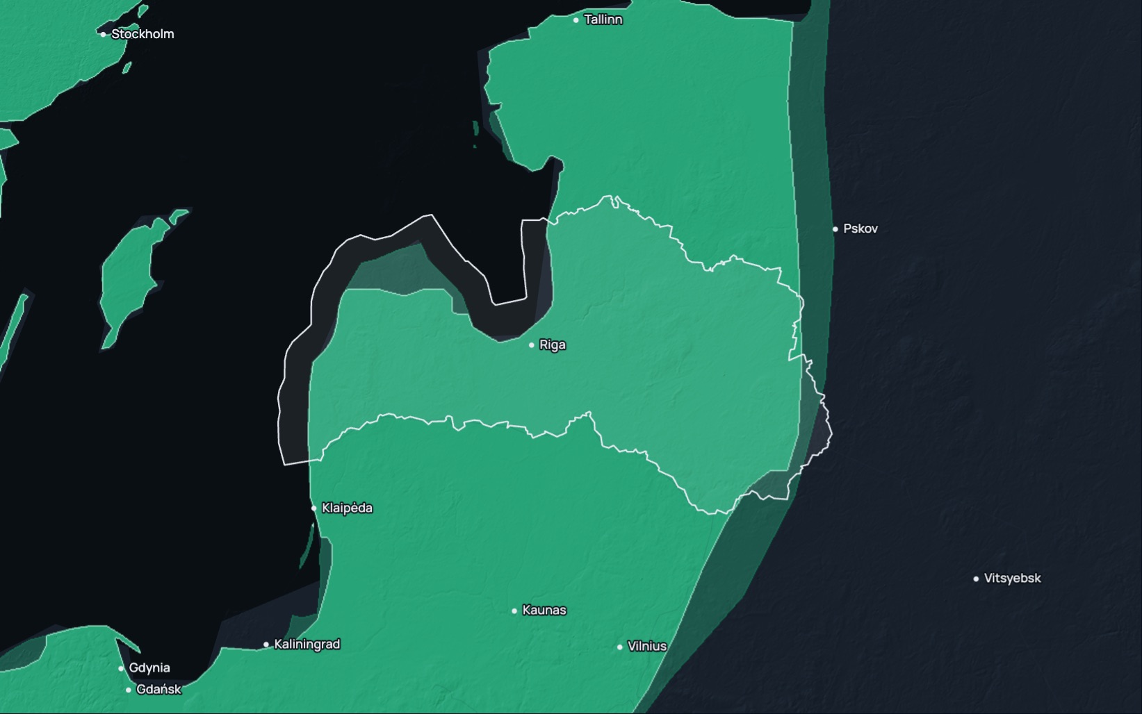
RTK Premium delivers network RTK corrections in Latvia in ETRS89 (ETRF2000, epoch 2010.0) over standard NTRIP. In a fixed solution it reaches under 1.5 cm horizontally and 2.5 cm vertically. 2+ networks serve most of Latvia, so smart failover takes over when a network drops, and the 99.9% monthly service level applies in the Eligible Area the coverage map shows. A small share of the country has 1 network, so check each site on the coverage map. A 14-day free trial comes first.
RTK Premium in Latvia
| Coverage | 2+ networks across most of Latvia; check your site on the coverage map |
|---|---|
| Frame | ETRS89 (ETRF2000, epoch 2010.0), ellipsoidal heights |
| Accuracy | Under 1.5 cm horizontal, 2.5 cm vertical, in a fixed solution |
| Service level | 99.9% monthly availability for RTK Premium in the Eligible Area the coverage map shows, with a refund of the monthly fee when a month falls short |
| Trial | 14 days on your own receiver; your account arrives by email within two working hours |
| Price | Priced per device and term. Request pricing |
| Support | Business days, 10:00 to midnight Latvian time |
| Stream | RTCM 3.x over NTRIP; caster rtkpremium.xyz, port 2101, mountpoint COMMON |
Check it before you commit
Setup guides
More than 100 step-by-step guides cover receivers, controllers, drones and machine control.
Test it yourself
RTKTEST.com compares up to three correction services against a surveyed point in one 15-minute session, and the 14-day trial runs on your own receiver at your own sites.
Correction services in Latvia
Latvian crews choose between the national mapping agency's positioning service, commercial network RTK, crowd-sourced base stations, satellite-delivered corrections and their own base.
| Type | Typical operator | What to check |
|---|---|---|
| National positioning service | The national mapping agency, for users registered on its service portal; it streams real-time corrections in LKS-2020 since 1 October 2026. | The terms for your sector, coverage near your sites, whether an availability commitment is published, and support hours. |
| Commercial network RTK | A private provider with stations across Latvia and beyond. | How many correction sources serve your area, the published service level and its remedy, the term, and whether a trial is offered. |
| Crowd-sourced network | Independent owners hosting single base stations. | Distance to the nearest base, station uptime, and how each base was surveyed. |
| Satellite or state-space (PPP-RTK, SSR) | A provider broadcasting an error model without a local base. | Convergence time, accuracy and vertical performance. |
| Your own base | Your crew, on a surveyed point. | The survey of the base point, range, and the time spent setting it up and guarding it. |
Coordinates and heights
RTK Premium delivers ETRS89 (ETRF2000, epoch 2010.0), with ellipsoidal heights. Since 1 October 2026, Latvian survey and cadastral data use LKS-2020, the national realisation of ETRS89 at epoch 2020.28, which replaced LKS-92. Plane coordinates use the LKS-2020 TM projection, with a central meridian of 24 degrees east and a scale factor of 0.9996. Heights are normal heights in LAS-2000,5, the national realisation of EVRF2007, so convert ellipsoidal heights with the national mapping agency's quasigeoid model. The agency offers an NTv2 conversion surface and a coordinate calculator for moving older LKS-92 data to LKS-2020. RTK Premium works at epoch 2010.0 and LKS-2020 at epoch 2020.28, so the two can differ slightly; check against a national control point before cadastral or control work.
Setup
- Start the 14-day free trial on this site, or order a subscription. Your account arrives by email within two working hours.
- Enter the caster rtkpremium.xyz, port 2101 and mountpoint COMMON in your controller or receiver, with the username and password from your account.
- Measure a control point you trust before the job starts, and compare the result with its published coordinates in your project's frame.
Industries using precise positioning or RTK corrections in Latvia
Farms: Latvia had 57.4 thousand active farms in 2023 on 1.97 million hectares of agricultural land, and large holdings managed 77.2% of the arable land. Drilling, spraying and harvest guidance on those farms depend on a correction that holds pass after pass. (Central Statistical Bureau of Latvia, Integrated Farm Statistics, 2023)
Civil works: Civil engineering output in Latvia rose by 25.7% at constant prices in 2025, and construction of roads and railways, bridges included, grew by the same share. Road, rail and utility works are staked out and checked against design. (Central Statistical Bureau of Latvia, Construction output, 2025)
Ports and haulage: Latvian ports loaded and unloaded 34.3 million tonnes of cargo in 2025, and road transport carried 80.3 million tonnes of freight. Quay works, dredging, depots and terminal layout are set out from surveyed control. (Central Statistical Bureau of Latvia, Transport sector in 2025, 2025)
Solar: Solar generation in Latvia reached 994 GWh in 2025, up from 7 GWh in 2021, and renewables produced 74.8% of the country's electricity. Solar parks are laid out, piled and checked from surveyed points. (Central Statistical Bureau of Latvia, Renewable energy consumption, 2025)
Questions about RTK in Latvia
Which RTK correction service serves Latvia?
RTK Premium covers most of Latvia with 2+ networks and a 99.9% monthly service level in the Eligible Area, and the coverage map shows the networks at any site.
Is there a free RTK network in Latvia?
The national mapping agency's positioning service needs registration on its service portal and works under the agency's own terms of use. Community networks host free single base stations of varying quality, so check what each source commits to on availability and support.
Which frame and heights should RTK corrections use in Latvia?
Use ETRS89, then convert to LKS-2020 TM coordinates and to LAS-2000,5 normal heights with the national quasigeoid model.
What changed when Latvia moved to LKS-2020?
LKS-2020 replaced LKS-92 on 1 October 2026, and new geospatial data are now collected only in LKS-2020. The national mapping agency offers an NTv2 conversion surface and a coordinate calculator for older LKS-92 data.
How much does RTK Premium cost in Latvia?
Prices depend on the number of devices, the term and the product, and we quote them after a short call. The 14-day trial needs no payment.
How accurate is RTK in Latvia?
In a fixed solution under good conditions, RTK Premium reaches under 1.5 cm horizontally and 2.5 cm vertically.
Can I try RTK Premium before I buy?
Yes. The trial runs for 14 days on your own receiver, with full access to the RTK Premium network.
Last updated: 12 November 2026
Try RTK Premium in Latvia
Run the 14-day trial at your own Latvian sites, in LKS-2020 TM with LAS-2000,5 heights, before you commit to a plan.