RTK corrections in Japan
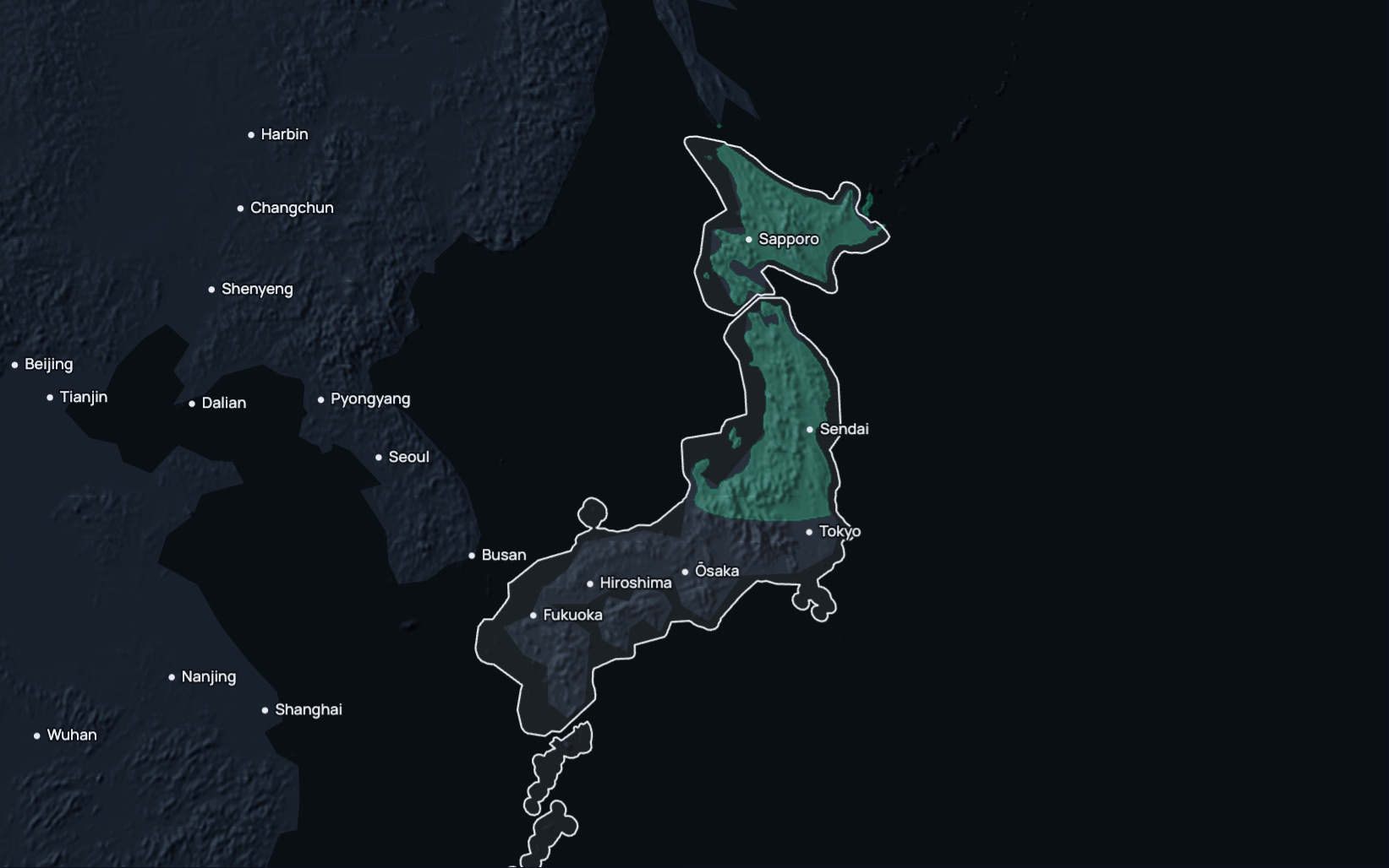
RTK Premium delivers network RTK corrections in Japan in ITRF2008, epoch 2005.0, over standard NTRIP. In a fixed solution it reaches under 1.5 cm horizontally and 2.5 cm vertically. Our coverage map for Japan is being revised, so confirm coverage at your site with us before you plan a job. The current map shows 1 network across Hokkaido and much of northern and eastern Honshu, and a site on 1 network has no second network to fall back to if that network drops. Prices depend on the number of devices and the term, and a 14-day free trial comes first.
RTK Premium in Japan
| Coverage | Our coverage map for Japan is being revised; the current map shows 1 network across Hokkaido and much of northern and eastern Honshu, and a site on 1 network has no second network to fall back to; confirm coverage at your site with us |
|---|---|
| Frame | ITRF2008, epoch 2005.0, ellipsoidal heights |
| Accuracy | Under 1.5 cm horizontal, 2.5 cm vertical, in a fixed solution |
| Service level | The 99.9% monthly service level for RTK Premium applies only in Eligible Areas, which need 2+ networks on the coverage map; the current map shows 1 network in Japan |
| Trial | 14 days on your own receiver; your account arrives by email within two working hours |
| Price | Priced per device and term. Request pricing |
| Stream | RTCM 3.x over NTRIP; caster rtkpremium.xyz, port 2101, mountpoint COMMON |
Check it before you commit
Setup guides
More than 100 step-by-step guides cover receivers, controllers, drones and machine control.
Test it yourself
RTKTEST.com compares up to three correction services against a surveyed point in one 15-minute session, and the 14-day trial runs on your own receiver at your own sites.
Correction services in Japan
Japanese crews choose between data from the national mapping agency's reference stations, commercial network RTK, the government's satellite augmentation signal, crowd-sourced base stations and their own base.
| Type | Typical operator | What to check |
|---|---|---|
| National reference stations | The national mapping agency, with 30-second data from its reference stations open for post-processing; private distributors supply its high-rate data for a fee. | Whether you need real-time corrections or post-processing, and what each distributor commits to on availability and support. |
| Commercial network RTK | A private provider with stations across Japan. | How many correction sources serve your area, the published service level and its remedy, and the term. |
| Satellite augmentation (PPP-RTK, SSR) | The government's regional satellite system, broadcasting a centimetre-level augmentation signal built from the national reference stations; it needs a dedicated receiver. | Receiver support, convergence time, accuracy and vertical performance. |
| Crowd-sourced network | Independent owners hosting single base stations. | Distance to the nearest base, station uptime, and how each base was surveyed. |
| Your own base | Your crew, on a surveyed point. | The survey of the base point, range, and the time spent setting it up and guarding it. |
Coordinates and heights
RTK Premium delivers ITRF2008, epoch 2005.0, with ellipsoidal heights. Japanese survey data use JGD2011 for horizontal positions, projected into the zone of the plane rectangular coordinate system that covers your site, one of 19 zones that a 2002 ministry notice defines. Since 1 April 2025, orthometric heights are JGD2024 heights: take the geoid height from the national mapping agency's Geoid 2024 model (JPGEO2024) away from the ellipsoidal height, and on remote islands with their own height origins, such as the Ryukyu and Ogasawara Islands, also apply its height reference conversion grid. Crustal movement moves positions in Japan from year to year, and the national mapping agency issues semi-dynamic correction parameters for survey calculations. Agree the transformation from ITRF2008 to JGD2011 with your receiver or software supplier, and check against a national control point before public survey or control work.
Setup
- Start the 14-day free trial on this site, or order a subscription. Your account arrives by email within two working hours.
- Enter the caster rtkpremium.xyz, port 2101 and mountpoint COMMON in your controller or receiver, with the username and password from your account.
- Measure a control point you trust before the job starts, and compare the result with its published coordinates in your project's frame.
Industries using precise positioning or RTK corrections in Japan
Rice: Paddy rice for grain covered 1,425 thousand hectares of Japanese farmland in 2025, and the harvest reached 7,790 thousand tonnes. Levelling, transplanting and auto-steer in those paddies depend on a correction that holds pass after pass. (Ministry of Agriculture, Forestry and Fisheries (MAFF), basic agriculture, forestry and fisheries data, 2025)
Farm size: Farms in Hokkaido had an average of 34.6 hectares each in February 2026, against 2.7 hectares across the rest of Japan, by provisional figures. Field boundaries, drainage and guidance lines on holdings of that size are set out from surveyed points. (Ministry of Agriculture, Forestry and Fisheries (MAFF), basic agriculture, forestry and fisheries data, 2026)
Auto-steer: Shipments of auto-steer systems for farm machinery in Japan reached 9,590 in the 2025 financial year, 3,690 of them to Hokkaido, alongside 5,400 GNSS guidance systems. Auto-steer holds a tractor to its line only as well as the correction behind it. (Hokkaido Government, Department of Agriculture, shipments of agricultural GNSS guidance systems, 2026)
Roads: Japan had 1,222,132 kilometres of general road at 31 March 2024, 1,036,102 of them municipal roads. Widening, resurfacing and drainage on those roads are staked and checked against design. (Ministry of Land, Infrastructure, Transport and Tourism (MLIT), road statistics, 2024)
Questions about RTK in Japan
Which RTK correction service serves Japan?
RTK Premium delivers network RTK in Japan, and our coverage map for Japan is being revised. The current map shows 1 network across Hokkaido and much of northern and eastern Honshu, so confirm coverage at your site with us before you plan a job.
Is there a free RTK network in Japan?
The national mapping agency makes 30-second data from its reference stations open for post-processing, and private distributors supply its high-rate data for a fee. The government's satellite system also broadcasts a centimetre-level augmentation signal, which needs a dedicated receiver.
Which frame and heights should RTK corrections use in Japan?
RTK Premium delivers ITRF2008, epoch 2005.0, so transform to JGD2011 and the plane rectangular zone for your site. Convert ellipsoidal heights to JGD2024 heights with the national geoid model, Geoid 2024 (JPGEO2024).
What happens if the network drops at my site?
Where the current map shows 1 network, a site has no second network to fall back to, and the receiver loses its RTK correction until the network returns. Keep your own base or another source ready for work that cannot wait.
How much does RTK cost in Japan?
Prices depend on the number of devices, the term and the product, and we quote them after a short call. The 14-day trial needs no payment.
How accurate is RTK in Japan?
In a fixed solution under good conditions, RTK Premium reaches under 1.5 cm horizontally and 2.5 cm vertically.
Can I try it before I buy?
Yes. The 14-day free trial runs on your own receiver and needs no payment.
Last updated: 12 November 2026
Try RTK Premium in Japan
Confirm coverage at your sites with us, then run the 14-day trial in the plane rectangular zone for each site before you commit to a plan.