RTK corrections in British Columbia
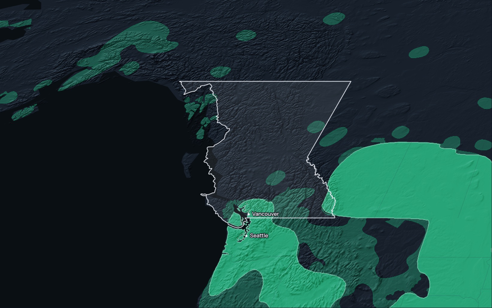
RTK Premium delivers network RTK corrections in British Columbia, Canada, in NAD83(CSRS), epoch 2010.0, over standard NTRIP. The coverage map shows networks across parts of southern British Columbia, in the southern interior and the southeast, and no RTK Premium network across northern British Columbia or most of the coast today. In a fixed solution it reaches under 1.5 cm horizontally and 2.5 cm vertically. Check each site on the coverage map, and run the 14-day free trial first.
RTK Premium in British Columbia
| Coverage | The coverage map shows networks over about 14% of British Columbia's land area, across parts of southern British Columbia in the southern interior and the southeast, with 2+ networks over about 5% and 1 network over about 9%; no network across northern British Columbia and most of the coast; check your site for 1 network or 2+ networks |
|---|---|
| Frame | NAD83(CSRS), epoch 2010.0; ITRF on request |
| Accuracy | Under 1.5 cm horizontal, 2.5 cm vertical, in a fixed solution |
| Service level | The 99.9% monthly service level for RTK Premium applies only in Eligible Areas, which need 2+ networks on the coverage map; most of British Columbia has no network |
| Trial | 14 days on your own receiver; your account arrives by email within two working hours |
| Price | Priced per device and term. Request pricing |
| Support | Business days, 00:00 to 14:00 Pacific Time (09:00 CET to 17:00 ET) |
| Stream | RTCM 3.x over NTRIP; caster rtkpremium.xyz, port 2101, mountpoint COMMON |
Check it before you commit
Setup guides
More than 100 step-by-step guides cover receivers, controllers, drones and machine control.
Test it yourself
RTKTEST.com compares up to three correction services against a surveyed point in one 15-minute session, and the 14-day trial runs on your own receiver at your own sites.
Correction services in British Columbia
British Columbia crews choose between the provincial government's active control data, regional government RTK services, commercial network RTK, crowd-sourced base stations, satellite-delivered corrections and their own base.
| Type | Typical operator | What to check |
|---|---|---|
| Provincial active control system | The provincial government, which provides post-mission data from its active control stations by subscription or per download. | Whether you need real-time corrections or post-processing, distance to the nearest station, and support. |
| Regional government RTK services | Two metropolitan regional districts, in partnership with the provincial government and their municipalities. | Coverage near your sites, access terms, which datum version each service delivers, and support hours. |
| Commercial network RTK | A private provider with stations across several provinces. | How many correction sources serve your area, the published service level and its remedy, and the term. |
| Crowd-sourced network | Independent owners hosting single base stations. | Distance to the nearest base, station uptime, and how each base was surveyed. |
| Satellite or state-space (PPP-RTK, SSR) | A provider broadcasting an error model without a local base. | Convergence time, accuracy and vertical performance. |
| Your own base | Your crew, on a surveyed point. | The survey of the base point, range, and the time spent setting it up and guarding it. |
Coordinates and heights
RTK Premium delivers NAD83(CSRS), epoch 2010.0, on every British Columbia connection, and ITRF on request. NAD83(CSRS) and NAD83(2011) are separate realisations of NAD83, so set Canadian projects and controllers to NAD83(CSRS) rather than the US frame. Legal surveys in British Columbia use the datum versions the Surveyor General approves, which correspond to epoch 2002.0 on the mainland and epoch 1997.0 on Vancouver Island, so transform RTK Premium positions before you tie them to provincial control or a legal survey. Legal surveys state coordinates in the UTM projection in the appropriate zone, and the provincial parcel fabric is published in NAD83(CSRS) UTM zones 7 to 11 and in the BC Albers projection. The province names CGVD28 as its current vertical datum, reached from ellipsoidal heights with the HTv2.0 height transformation model, and it is implementing a new system that will change benchmark elevations. Set the project, the controller and the correction service to the same frame, epoch, zone and height datum before the job starts.
Setup
- Start the 14-day free trial on this site, or order a subscription. Your account arrives by email within two working hours.
- Enter the caster rtkpremium.xyz, port 2101 and mountpoint COMMON in your controller or receiver, with the username and password from your account.
- Measure a control point you trust before the job starts, and compare the result with its published coordinates in your project's frame.
Industries using precise positioning or RTK corrections in British Columbia
Field crops and hay: British Columbia had 15,841 farms in 2021, and they reported 1.3 million acres of field crops and hay, led by 404,770 acres of other tame hay and fodder crops and 379,069 acres of alfalfa. Seeding, cutting and baling on that ground run guidance that needs a correction holding pass after pass, so check each field on the coverage map first. (Statistics Canada, Census of Agriculture, 2021)
Orchards and vineyards: British Columbia had 7,046 acres of sweet cherries on its farms in 2021, 94.7% of Canada's total, along with 12,829 acres of grapes and 27,008 acres of highbush blueberries. Orchard and vineyard blocks are planted in rows that are set out from surveyed lines. (Statistics Canada, Census of Agriculture, 2021)
Forestry: British Columbia's annual timber harvest has declined since 2014 from 71 to 39 million cubic metres, and over the last 20 years the harvest on public land averaged 60 million cubic metres a year against an average Allowable Annual Cut of 77 million. Cutblocks, resource roads and replanting are laid out from surveyed points, so check each block on the coverage map first. (Government of British Columbia, Environmental Reporting BC, 2025)
Mining: More than 40,000 people work directly in British Columbia's mining sector, and the province saw nearly 751 million Canadian dollars of mineral exploration spending in 2025, with 187 companies active in 301 projects. Mine sites, haul roads and exploration grids are staked from surveyed control, so check remote sites on the coverage map first. (Government of British Columbia, Ministry of Mining and Critical Minerals, 2026)
Questions about RTK in British Columbia
Which RTK correction service serves British Columbia?
RTK Premium serves parts of southern British Columbia, in the southern interior and the southeast, with network RTK in NAD83(CSRS), epoch 2010.0. The coverage map shows no RTK Premium network across northern British Columbia or most of the coast today, so check each site before you plan a job.
Is there a free RTK network in British Columbia?
The provincial government sells post-mission data from its active control stations by subscription or per download, and two metropolitan regional districts run their own RTK services with the province. Community networks host free single base stations of varying quality, so check what each source commits to on availability and support.
How much does RTK Premium cost in British Columbia?
Prices depend on the number of devices, the term and the product, and we quote them after a short call. The 14-day trial needs no payment.
Which reference frame and epoch do I use in British Columbia?
RTK Premium delivers NAD83(CSRS), epoch 2010.0, with ITRF on request, while legal surveys refer to the provincial datum versions at epoch 2002.0 on the mainland and 1997.0 on Vancouver Island. Transform between them before you tie work to provincial control, and state coordinates in the UTM zone for your site.
Does RTK Premium cover northern British Columbia?
No. The coverage map shows no RTK Premium network across northern British Columbia or most of the coast, so plan work there with your own base or another source.
How accurate is RTK in British Columbia?
In a fixed solution under good conditions, RTK Premium reaches under 1.5 cm horizontally and 2.5 cm vertically.
Can I try it before I buy?
Yes. The 14-day free trial runs on your own receiver and needs no payment.
Last updated: 12 November 2026
Try RTK Premium in British Columbia
Run the 14-day trial at your own sites in southern British Columbia, in your own UTM zone, before you commit to a plan.